Waterspout Caught On Video Near Mackinac Bridge Over Lake Huron
Yesterday, people near or around the Mackinac Bridge got quite a sight during a patch of bad weather.
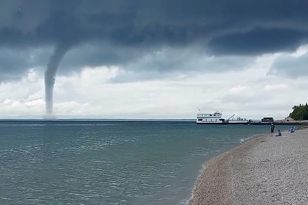
Around 11 am, near the North anchor pier close to the Mackinac Bridge, a clear and defined waterspout was spotted. The photo was shared by the Twitter account @mackinacbridge:
A formidable sight, to be sure. But, not nearly as crazy as this video caught from someone on the beach where the waterspout formed:
I'm impressed with the people calmly standing on the shore filming this thing. I would have been RUNNING out of there.

The National Weather Service in Gaylord had previously issued a Special Marine Warning over Lake Huron and later confirmed that a waterspout had, indeed, formed. Thankfully, there are no reports of injuries or damage.
Was Anyone in Danger?
It really depends.
The National Weather Service divides waterspouts into two different categories:
- Fair Weather Waterspouts
- Tornadic Waterspouts
Fair Weather Waterspouts are usually less dangerous and are more common than Tornadic Waterspouts. They form from the surface of the water up, usually in light wind conditions, and move very little. If they do make it to land, they usually dissipate.
Tornadic Waterspouts are tornadoes that form over water. They have the capability of traveling from water to land and are usually associated with severe thunderstorms.
Watch: Chicago Area Live News Broadcast Catches Tornado Forming Over O'Hare International Airport
Read more about both types of waterspouts, what to do if you're in the water when they form, and more here.
As always, to ensure your own safety, make sure you follow guidelines and heed warnings from the National Weather Service or your local weather service before, during, and after severe weather.
Michigan's Worst Natural Disaster: the 1953 Flint-Beecher Tornado
Tornadoes in Michigan, Early 1900s
More From WKFR